


This time of year is all about looking to the future. We have 12 fresh chapters to fill with adventures, so naturally, it’s time to take a look at the goal hikes on those bucket lists and see what’s possible in 2024. This year, we—the editors at Backpacker and Outside—are dreaming big. On our bucket lists, we have birthright trips to one of the most iconic mountain ranges in the world, treks inspired by the pages of Backpacker, re-dos after previously failed adventures, and more. These are the hikes that hold top billing on our editors’ bucket lists.
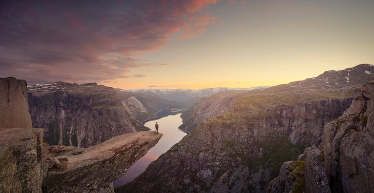
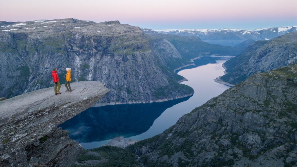
I have technically been to Norway, but not really. In 2018, my family flew to Oslo to explore before visiting other Scandinavian countries. However, I got a bad bout of food poisoning that set in on the flight, and my only memories of Norway are from the hotel bed. While I was sick, I watched a program on the hotel television about a hike called Trolltunga (the troll’s tongue), and in that moment, it jumped to the top of my bucket list. I wanted a redemption trip to Norway, and this seemed like a good enough reason to return. In general, I don’t rush to the Instagram-centered trails, but this one offers more than just the photo op itself: During the ice ages, a glacier carved through what would now be known as the Hardangervidda mountain plateau, leaving behind a valley and a tongue-like rock structure jutting off the edge of the cliff. Sure, all hikes aren’t about the destination, even with a hike as destination-forward as this one. The journey here is worth it too: In order to get to the picturesque tongue, you have to hike roughly 17 miles with almost 2,600 feet of elevation gain from the main trailhead in Skjeggedal. This trail feels playful—the trail markers with trolls on them help give them a sense of childlike glee—and hopping from boulder to boulder along sections of this trail will take me back to my elementary school playground. You put in a sweat, too, by climbing the first 4 miles without much respite, but along the way if you need a moment of zen, look below at the glistening Ringedalsvatnet lake. —Emma Veidt, Assistant Editor
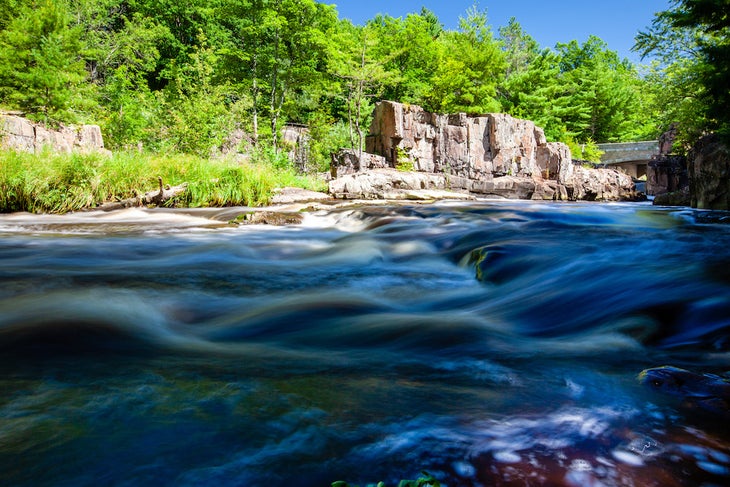
As a kid growing up in northern Illinois, some of my earliest outdoor memories were family camping trips among the oak woodlands and lakes of Wisconsin. What better way to make my return than by thru-hiking the Ice Age Trail? The 1,200-mile-long path crosses the state following the last ice age’s terminal moraine, a long range of hills formed by the scouring action of glaciers, and has become one of the newest units of the National Park Service. Starting at the trail’s terminus at Sturgeon Bay by the shores of Lake Michigan, I’d hike west, hopping between quiet forests, rolling meadows, and rail trails, connecting them with still-mandatory roadwalks where gaps in the trail exist, until I reached the route’s western end on the St. Croix River. Some sights I’m looking forward to: the 11-mile Devil’s Lake segment, where the trail winds over tall quartzite cliffs; the Dells of the Eau Claire, where the path crosses a bridge 30 feet over a river; and the side trail to Wisconsin’s highest point, 1,951-foot Timm’s Hill, and the view from its observation tower. Just thinking of it all warms my Midwestern heart. —Adam Roy, Executive Editor
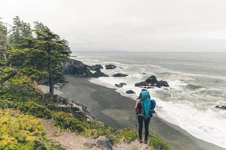
The pages of Backpacker motivated me to take my first backpacking trips as a teenager, and as an editor, I’m still inspired by the stories we publish about trails around the world. I first learned about the West Coast Trail from this story we originally ran in print a couple of years ago. I was intrigued by the trail’s deep historical significance and dramatic photos of foggy, driftwood-strewn beaches. Recently, the West Coast Trail popped back on my radar when Lance Garland wrote about finding peace and healing during his hike. Most of my hikes take me into the alpine, but this trail offers hikers an intimate experience with the moss, roots, and mud of the coastal rainforest punctuated by beach walks and views over the Salish Sea and the Pacific. One can watch whales breaching off shore from campsites on the beach, cross creeks using cable cars installed along the trail, and wander through the remnants of shipwrecks. It feels like a backpacking trip unlike any I’ve taken before. Backpacker writers haven’t led me astray yet. Time to start looking for permits. —Zoe Gates, Senior Editor
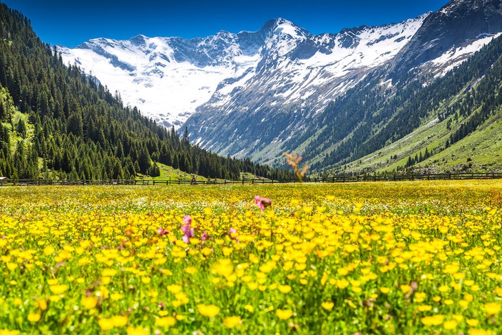
My grandmother’s family hails from Austria (or what is now considered modern-day Austria), and I have always been overly keen to visit. I’m inspired to visit the country and hike through the Alps as a trip into my family’s past. After hiking through the Dolomites twice I am itching to get back to the splendors of the Alps. My loose plan for the trip is to start and end in Vienna, allowing a day or two to explore the city, visit palaces, and recover while strolling the cobblestone streets. From there, I’d head to Wolfgangsee Lake, and while in the area, of course I’d also stop in for a Sound of Music tour because when in Rome (or Austria). From there the real hiking begins. I simply cannot narrow it down to where yet, but Spuller Schafberg Peak in the Lechquellen Mountains, Innergschlöss Glacier Trail in Hohe Tauern National Park, and Gamsjoch Peak in the Karwendel Mountains all seem incredibly picturesque. Along the way, I’ll be thinking of my grandmother and those who came before her; all of whom have shaped me in more ways than I’ll ever know. —Jamie Aranoff, Digital Editor, SKI Mag
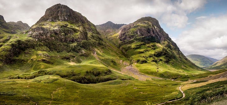
I’m a fan of hiking and camping in the cold. I’ve trekked in Greenland, the high Canadian Arctic, Patagonia, South Georgia Island, Antarctica, and many winter outings in my home state of Colorado. So it’s only natural that Scotland’s West Highland Way is on my list of bucket-list destinations. Bonus points if I can have a border collie or two join me on the trek. The trail is only 96 miles—relatively short for a life-list backpacking trail, in my opinion—but it’s one that I’d like to take my time on and explore every possible diversion. That includes the towns and villages serving as wonderful waypoints in the wilderness. The combination of ancient roads, deep history, minimalist landscapes, and potential sheepdog sightings make for a very different adventure from my usual, brief Colorado outings or the absolute remoteness of my Arctic travels. Call it the best of both worlds, with the added perks of warm pubs and optional summits along the way. —James Dziezynski, SEO Director, Outside
From 2023
