


Do you consider hiking a 365-day-per-year sport? We do.
All it takes is some local intel and well-thought-out planning to pick the perfect trail for the time of year you plan to hike. From timing your trips to coincide with prime leaf peeping and wildflower superblooms to trading snowed-in trails for tropical thru-hikes, every month can be the best month to hike if you plan for it.
Our 2024 hiking calendar takes a variety of different approaches, from hitting up lesser-known (and less-crowded) trails during peak months to swapping the northern hemisphere for the south during our winter. For each month of 2024, we’ve picked out one of our favorite hikes across the U.S. and abroad. Where will you choose to go this year?
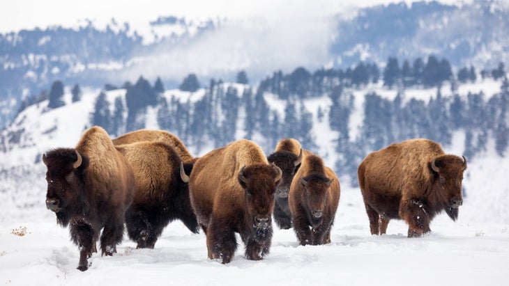
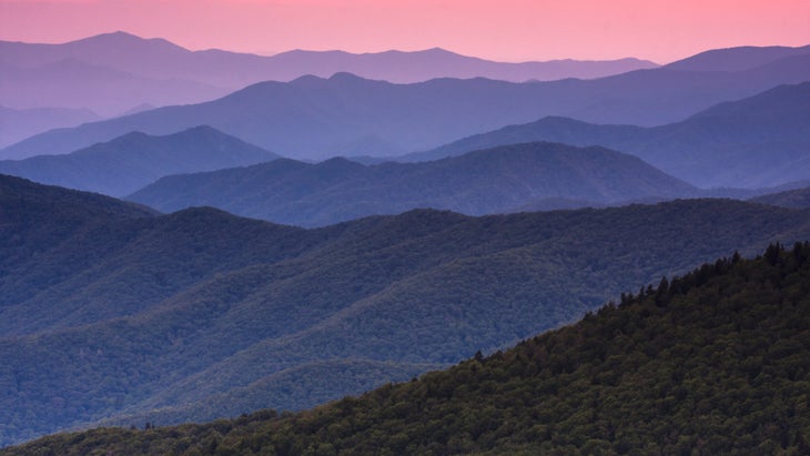
Take in the wonder of winter at Yellowstone National Park with an early-season visit—all while skipping the summer crowds and traffic on Grand Loop Road. Soak in solitude on the Beaver Ponds Trail (5 miles) while hiking or snowshoeing beneath billows of steam rising from the geothermal Mammoth Hot Springs or catch stunning snowy views of the Yellowstone River Narrows on the Yellowstone River Overlook Trail (4.7 miles). Post-hike, warm up with a hot spring soak at Chico Hot Springs in Pray and Hot Springs State Park in Thermopolis. Heads up: The road between the north and northeast entrances is open year-round to automobiles, but smaller park roads are limited to snowmobiles and guided snowcoach only between mid-December to mid-March.

Known for its vast tropical rainforest, cascading waterfalls, and stunning sea cliffs, the Nāpali Coast is a stunning example of how Kauai got its nickname, “The Garden Isle.” Due to its popularity, you’ll need a permit to hike the 24-mile coastal Kalalau Trail in Nāpali Coast State Wilderness Park. The jungle trek is flanked by endless views of the Pacific Ocean, lush green cliffsides that plunge into the water, and hidden narrow valleys: a true hiker’s paradise. Miss out on a coveted backpacking permit? Take a dayhike out and back to Hanakāpīʻai Beach (4 miles) or up to Hanakāpīʻai Falls (8 miles). Heads up: You need to book a day-use reservation for dayhikes too.
There’s no better time to visit the southwest than in the spring. Challenge yourself with a thru-hike across the entire Grand Canyon State on the Arizona National Scenic Trail—an 800-mile route that spans from the U.S.-Mexico border to Utah. Backpacker contributor Liz “Snorkel” Thomas completed the trek in 2023 and recommends aspiring Arizona Trail thru-hikers start their journey northbound to avoid late-season heat. It’s not uncommon to run into snow and ice in March—especially for northbounders hiking above 9,000 feet up the spine of the Huachuca Mountains on day 1. (Later spring can bring hot temperatures, but beautiful sights, too: By April, swaths of vibrant wildflowers like orange globemallows, bright yellow brittlebush, and ombre Mexican gold poppy light up the desert floor.) Want to try a bite-sized chunk of the AZT? Tackle the Walnut Canyon Passage, a 17.5-mile segment southeast of Flagstaff offering respite from the heat as it travels through the heavily pine-oak wooded Coconino National Forest.

The Golden State turns green come April in San Luis Obispo—a hiking haven with rolling hills that resemble the Irish countryside. Roughly halfway between San Francisco and Los Angeles, “SLO” (as the locals call it) boasts dozens of trailheads you can walk or bike to right from the city center. Make it your basecamp with a mix of dayhikes that range from chill to challenging, like the easy Ridge Trail (1.5 miles) at South Hills Natural Reserve, the moderate Cerro San Luis Obispo Loop (5.7 miles) that tops out at the summit of Madonna Mountain with panoramic views of downtown, or the strenuous Reservoir Canyon Loop (5.5 miles) in the Santa Lucia foothills that finishes with 800 vertical feet in the final mile. If you want to squeeze some coastal hiking in, visit Montaña de Oro State Park and hike the Hazard Peak to Islay Creek Loop (9.2 miles)—a coastal canyon hike that leads to a summit view of Morro Bay. Bonus: You may catch sight of the California superbloom that peaks this time of year.
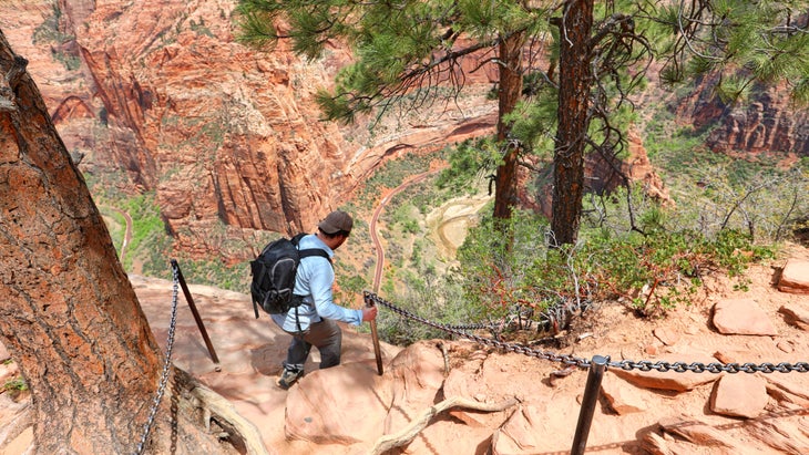
Like Arizona, southern Utah sees its fair share of sweltering heat come summertime. Head to Zion in spring when daytime averages hover in the 70s and the rainy season ushers in flowing waterfalls and radiant green foliage along the banks of The Virgin River. Water levels at popular canyon hikes like The Narrows and The Subway may be too high to hike early in the month but typically thin out by the end of May. Trailhead-hop on the park’s free shuttle buses, which travel between the visitor center and the end of Zion Canyon Scenic Drive. You can also rent an e-bike—my favorite way to get around the park—from Zion Guru. May is also a prime time for backpackers to snag a permit for the West Rim Trail, a 16-mile point-to-point route that showcases the park’s expansive views of towering plateaus, orange and white striped sandstone, natural arches and winding canyons. Pro tip: Tack on Angel’s Landing at the end of the hike once you reach Scout Lookout—but note a permit is required.
There’s a reason June marks the start of the busy season in the Smokies. Wildlife, waterfalls, and wildflowers reach their peak in early summer, and the seasonal temperate weather makes for dry and cool hiking. Consider thru-hiking the 300-mile Benton MacKaye Trail—affectionately known as the Appalachian Trail’s little sibling. Although June marks the start of the Smoky Mountains’ busy season, you can escape some of the crowds on this remote route that shares a starting point with the AT at Springer Mountain in Georgia. It makes its way across the Smokies with 93 miles extending through the national park—making it the longest trail in the park.
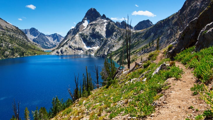
It’s hard to beat summer in the Sawtooths, where the days are long, the nights are warm, and cool dips in alpine lakes are a must. Popular trails like the Chocolate Gulch Trail (4.8 miles), Pioneer Cabin Trail (8 miles), and Bald Mountain Trail (11 miles) show off the character of the Sawtooth Range: stunning jagged peaks, radiant glacial lakes, snowmelt creeks, and complete solitude. Sans national park status, Sawtooth National Forest sees fewer crowds than its Northern Rockies counterparts like Glacier National Park and Yellowstone National Park, but it boasts equally gorgeous views, challenging trails, and abundant wildlife.
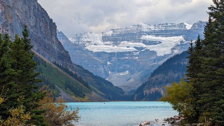
Backpack and dayhike your way through Banff National Park—the crown jewel of the Canadian Rockies—while marveling at brilliant blue alpine lakes along the way. By July and August, snowmelt reaches its highest level and spills into lakes, streams, and waterfalls on its way down from the park’s ice-capped peaks. The glacial runoff turns the water a vivid ice-blue color—a result of highly reflective “glacial milk” caused by suspended “rock flour”—small particles of glacially-ground stone—in the water. Coveted trails to see the phenomenon include Lake Agnes Trail (4.5 miles), Bow Glacier Falls (5.5 miles), and Plain of Six Glaciers Trail (9 miles) near Lake Louise. Want a longer-distance route? Try out the Paradise Valley Circuit, a challenging 13-mile point-to-point hike that connects Moraine Lake and Lake Louise with unreal views of craggy peaks and glacial-blue waters throughout the entire route.
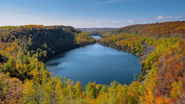
Spot early fall foliage on the Superior Hiking Trail, a less-traveled midwestern thru-hike that follows Lake Superior’s North Shore and through eight state parks in Minnesota. The rugged 310-mile route explodes with color by the third week of September and stays that way through early October. Along the way, you’ll take in endless views of Lake Superior—the coldest, deepest, and largest of the Great Lakes—as you wind in and out of remote wilderness scattered with birch, aspen, pine, and cedar. Be warned: Black flies and mosquitoes are gnarly here in late summer, so come prepared with repellent and bug nets if they’re still buzzing around before the cold snap.
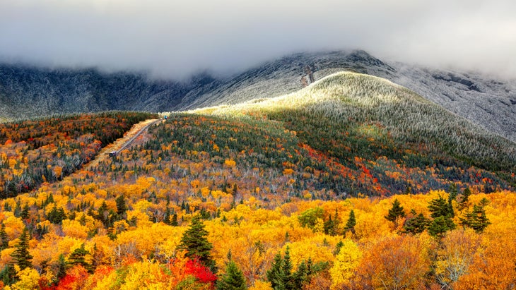
Come October, a blanket of fall foliage covers the northeast. But where can you find the best leaf peeping? In White Mountain National Forest, an 800,000-acre slice of pristine woodlands in New Hampshire. If you’re a purist, hike some or all of the 89.5 miles of Appalachian Trail that run through the White Mountains. Peak baggers can get a start on the Appalachian Mountain Club (AMC) Four Thousand Footer Club on their choice of 48 White Mountain Four Thousand Footers, dayhikers can explore the heart of the Wild River Wilderness on the Wild River Loop (8.2 miles), and cabin lovers can follow the Nineteen Mile Brook Trail (7.5 miles) to Carter Notch Hut, which requires a reservation but includes creature comforts and meals with your stay.
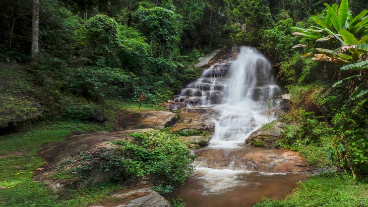
Trade winter’s chill for tropical treks in Southeast Asia at Doi Suthep–Pui National Park. Situated outside the mountainous city of Chiang Mai in northern Thailand, this national park surrounds the Buddhist Doi Suthep Temple, a golden 79-foot, brass-plated masterpiece that pops against the mixed deciduous-evergreen forest. Popular hikes throughout the park include the Doi Suthep Monk Trail (4.5 miles) and the ancient Wat Phra That Doi Suthep temple, mong lychee, and mango grove-surrounded Dtaat Mook Waterfall Loop (3.4 miles). Hurricane and typhoon seasons slow down by November, and northern Thailand sees less heat and humidity this time of year too.

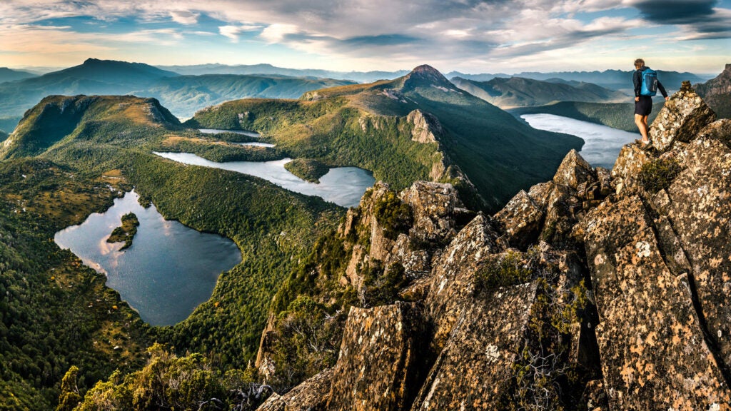
Soak up summer in the Southern Hemisphere with an escape to Tasmania, Australia’s smallest and least-populous state. December through February mark the warmest months there, with average temps in the low 70s during the day and mid-60s at night. Beat the crowds of the popular Overland Track by opting for the lesser-known Western Arthur Range Traverse: The around 50-mile lollipop loop trail is filled with challenging boulder scrambles and steep climbs to summit ridges, but it pays off with expansive views of Tasmanian wilderness dominated by buttongrass moorland, alpine scrub, and jagged quartzite mountain peaks. You’ll need a permit to enter the park, and year-round, you’ll need registration to hike the route.
From 2024
