


Every year is a good hiking year here at Backpacker, but this year was better than most. With our company declaring Fridays off throughout the summer, we had an extra day through the year’s warmest months to go explore. When we logged back on for the week, everyone had an epic story to tell. This year, we shared memories from hometown overnighters, international treks, and more, but as we’re closing in on the end of the year, we’re reflecting on the best of the best. Here are the six adventures we’ll never forget—plus how to do them yourself.
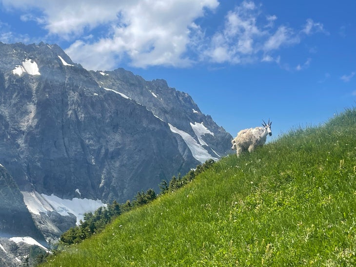
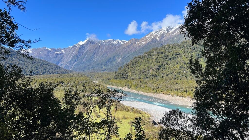
In one of my best hiking seasons in recent memory (thanks for the Summer Fridays, Outside), one hike stands out. This foray into North Cascades National Park made me feel like I’d stepped into the Alps. Under a crystal-clear sky, I discovered the pure magic of summer in the Pacific Northwest. After gradually ascending through the forest, the trail bursts into the alpine with views of jagged granite ridgelines, streaming waterfalls, and glacier-carved valleys. Climbing above Cascade Pass, I hiked by mountain goats trailed by fluffy white kids. I peered into emerald Doubtful Lake from high above and walked between lupine and fireweed, then ate my lunch reclined on a rock in view of rippling glaciers. Butterflies flitted around my head while I navigated the gravelly switchbacks. It took all my willpower to not break out into song from The Sound of Music. With views over some of the most iconic peaks of the Cascades, this is a great place to scope out the next adventure.
Hike It: This is one of the most popular hikes in Washington, and for good reason. I didn’t mind sharing the trail with others on a perfect summer day, but if you prefer solitude, avoid weekend days during the high season. Get an early start to ensure parking at the Cascade Pass Trailhead. Some hikers turn around at Cascade Pass about 3.5 miles in, continuing up the Sahale Arm is well worth it. While the 12-mile round-trip, 4,000-foot out-and-back is a very reasonable dayhike, there are a handful of campsites at the toe of the Sahale Glacier for the lucky few who score a permit. —Zoe Gates, Senior Editor
Growing up within an hour of the Pacific Crest Trail, many of my first times sleeping in a tent were along the PCT with my Girl Scout troop. Now, I sure to backpack part of that long trail at least once a year. The views stay the same, but I appreciate them differently in each season of life. This year, I decided to go on an overnighter around Eagle Rock. There’s no mistaking it: It’s as if Medusa turned a 20-foot-tall eagle with its wings completely outstretched into granite. Seeing the rock was by far my favorite part of the hike, but everything else was well worth the trip. Once I arrived in Warner Springs, I hiked south, passing riparian oak-lined creeks, chaparral and grass-covered rolling hills, and cacti, which is all standard fare for southern California hiking. I continued on for another 10 miles, crossing fields with cows grazing in the distance and through a couple more road crossings before deciding to set up camp for the night. This hike reminded me of everything I love about hometown hiking, and I got to drive into Julian for some famous apple pie on the way home.
Hike It: Park on the dirt road shoulder outside the fire station along CA-79 in Warner Springs. This is a popular trail for dayhikers, so you’ll have to arrive early to secure a parking spot. The PCT crosses this road, so once you pass the livestock gate, begin hiking south and follow the trail markers. It’s a little over 3 miles to reach the granite eagle, which you can’t miss because there’s a clear path heading uphill to the rock formation. (This is a great lunch or sunscreen break spot.) Because it’s the PCT, you can keep going for as long as you want, as long as you’ve got the necessary permits for dispersed camping. Eagle Rock is within Cleveland National Forest, which requires overnight permits. —Emma Veidt, Assistant Editor
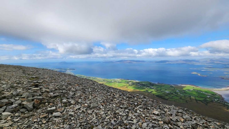
I grew up on Ireland’s west coast, so returning to climb my favorite mountain—this time with my husband—wins my 2023 hiking trophy. Croagh (pronounced “crow”) Patrick, a pyramid-shaped quartzite peak, overlooks 365 islets in the Atlantic Ocean’s Clew Bay and rises so dramatically, it makes all else appear tiny. We went in September knowing it’d be Russian-roulette weather, and spent most days decked out in rain gear, squelching along beaches near the fishing village where I’d lived. But, as luck had it, the morning we planned to bag the 2,507-foot summit, dawn broke with sunshine and mild wind. A rarity. Joyfully, we grabbed our hydration vests, jumped in our Fiat Panda rental, and hauled to the trailhead. The out-and-back climb itself is only about 4.5 miles round trip, but it follows an unforgiving shale footpath straight up the mountain. After a leg-burner on the west slope, you hug an exposed saddle before summiting from the east. My favorite part, other than childhood flashbacks slogging through snow, sleet, fog, and hail to the apex? Relishing views of the bay below, polka-dotted with emerald isles, while holding my husband’s hand.
Hike It: This hike is tough to get to, but worth the effort. Tackle the plane-train-automobile rigamarole to Westport. Then, take the oceanside R335 (Reek Road) six miles west to Croagh Patrick Visitor’s Center in Murrisk. You can hike this permit-free trail year round in a handful of hours, though you’ll wear solid boots and carry water and rain gear. (If you loathe crowds, skip hiking on Easter Week, when more than 30,000 pilgrims climb to the small white church at the top. Legend has it, St. Patrick ascended sometime in the fifth century to drive out the snakes from Ireland, and as such, it’s a holy mountain for many.) Hit up Campbell’s pub for a post-hike pint at the base, and stop by the National Famine Memorial, a haunting bronze-ship depiction of emaciated skeletons erected for those who fled Ireland during the 1840s potato blight, across the street. —Patty Hodapp, Senior Digital Travel Editor, Outside

As someone who’s spent his entire adulthood in the Mountain West, I sometimes daydream about what my life would have been like if I had decided to light out for the coast instead. I got to live out my salt-kissed, sunburned fantasies on an overnight paddling trip to Rabbit Key, a small, National Park Service-administered island off the coast of the Everglades, this February. My wife, our three-year-old son, and I launched our rented canoe shortly after sunrise and rode the outgoing tide across Chokoloskee Bay and through a maze of mangroves before emerging into the open Gulf of Mexico. After stretching our legs on Turtle Key, we paddled the last mile to Rabbit Key, where we pitched our tent underneath a mangrove above the high tide line and spent the rest of the day exploring. The island’s sandy fringes and shallows were thick with all kinds of marine life: Lightning whelks crept through the surf while fiddler crabs picked their way through the sand. In the island’s protected nooks, courting horseshoe crabs congregated in gigantic, crawling piles. While the occasional boater or kayaker ambled by during the day, by the time the sun sank below the horizon, we had the island all to ourselves. When the rest of my family turned in for the night, I crept back onto the beach, lit a driftwood fire, cracked open my copy of A General History of the Pyrates, and waited for the waves to lull me to sleep.
Do It: You don’t need to be an expert canoeist to make the trip out to Rabbit Key: As long as you’re relatively comfortable with a paddle in your hand and diligent about checking the weather, it’s a fairly novice-friendly trip. Reserve a canoe camping package from Chokoloskee Island’s Everglades Area Tours ($325 for 2 days/1 night; includes everything but food and a satellite communicator or PLB) and pay the $10 launch fee to put in from Smallwood Store, which saves a mile of paddling around the island versus the public marina. From there, it’s a 5-mile paddle through a labyrinth of mangroves (keep an eye on your charts to avoid dead ends) and along the edge of the open Gulf of Mexico. Rabbit Key has a portable toilet but no dock or other infrastructure, and you’ll need to pack in your water. Pro tip: Time your arrival and departure to take advantage of the tides, and keep in mind that the offshore winds that kick up in the afternoon can make the return trip a little more challenging. Reserve your permit through Recreation.gov ($21 reservation fee plus $2 per person). —Adam Roy, Executive Editor
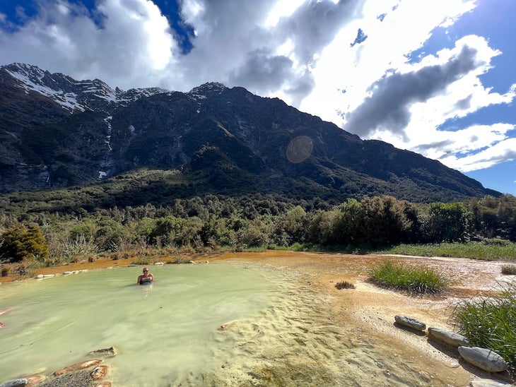
Among the dozens of incredible hikes I enjoyed on a recent monthlong trip to the south island, this overnight out-and-back hike is one I won’t soon forget. The 11.2-mile hike is spectacular as you head up the valley along the impossibly blue Copland River framed by snow-capped peaks and through lush forest teeming with birdsong. After several suspension bridge crossings and about 7 hours, you’ll arrive, tired but smiling, at Welcome Flat Hut. It sleeps 31 people and features a nice, wood-heated common room and big communal kitchen with good water, counter space, and sinks for washing. (BYO cooking gear, stove, and fuel). In the warm months, there’s even a flush toilet. But what sets this hike truly apart is the steamy natural hot spring at the hut. Is there a better way to end a day of hiking? Not in my book.
Hike It: The track (as they say in New Zealand) is well marked and not difficult, but it’s a long day on the way in. You need to reserve your bunk ($30 NZ per night) or campsite ($15 NZ), so be sure to either stop in at the Department of Conservation office in nearby Haast or Franz-Josef or book online. You’ll want a nice weather window for this hike, as the creeks are prone to flooding and the steep valley walls see a lot of landslides. —Kristin Hostetter, Contributing Editor and Head of Sustainability, Outside
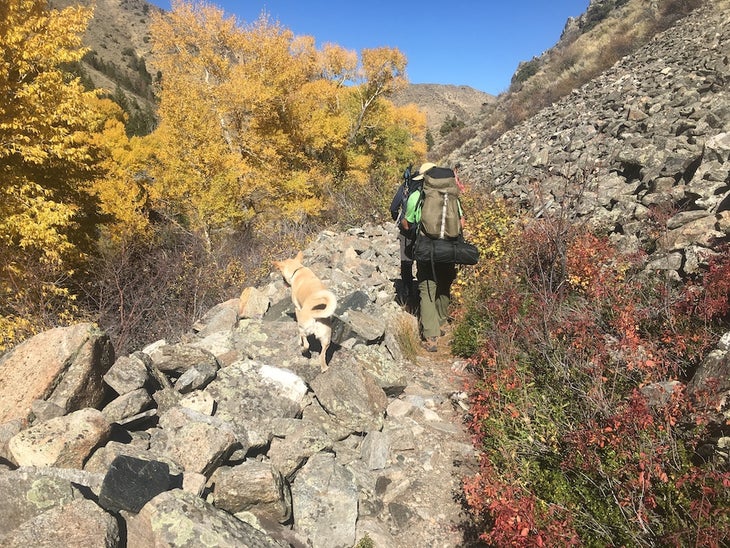
When I look back at 2023, choosing a favorite trip is like choosing a favorite kid: impossible. This was a banner year for big trips. In the spring, I hiked in all five Utah national parks in a single week—a little crazy but a lot of fun. At the end of summer I spent 10 days rafting the Colorado River through the Grand Canyon. And I capped it off with a trek in Nepal, in the little-known Nar Phu Valley. Any of these life-list adventures would be easy to call my favorite. But I also went on a “normal” backpacking trip that makes the cut. That’s because I found a place that checks all the boxes for a close-to-home hike in the fall. I live in Boulder, Colorado, and fall in the Rockies is beautiful but the weather can be cold and wet up high in October. I’ve been on the hunt for a good option that’s within a few hours’ drive, at a moderate elevation, with great fall colors and of course no crowds. I found it all on the Encampment River Trail, near the Colorado/Wyoming border. The 16-mile route bisects the Encampment River Wilderness and hugs the water the whole way. I went there for a long weekend with almost a dozen friends and family, and we found great camping just a few miles in, on a large flat bench alongside the river. The cottonwoods were golden, the weather perfect, and everyone could choose their own adventure: hike upstream for miles, fish the many tempting trout holes, or just lounge in camp and watch the leaves come down.
Hike it: The most accessible trailhead is at the northern end, adjacent to the Encampment River campground (the dirt road is passable to passenger cars). It’s called the Encampment River Trail trailhead (or the Oddfellows trailhead because of a nearby collection of private cabins). From the town of Encampment, take State Highway 70 south and just outside of town go left on County Road 353/Finley Hill Road and stay left to reach the trailhead after about a mile. No reservations or permits needed; self-register at the trailhead. The trail starts at just under 8,000 feet elevation, and from there you hike upstream, gently climbing the canyon bottom. You’ll find camping intermittently along the river throughout the wilderness, but the canyon gets steeper and more forested about 5 miles in, after which options get a little more sparse. You can do this hike as an out-and-back or a point-to-point (the southern trailhead is Commissary Park). Find more info here. —Dennis Lewon, Director of Custom Content, Outside
From 2023
