


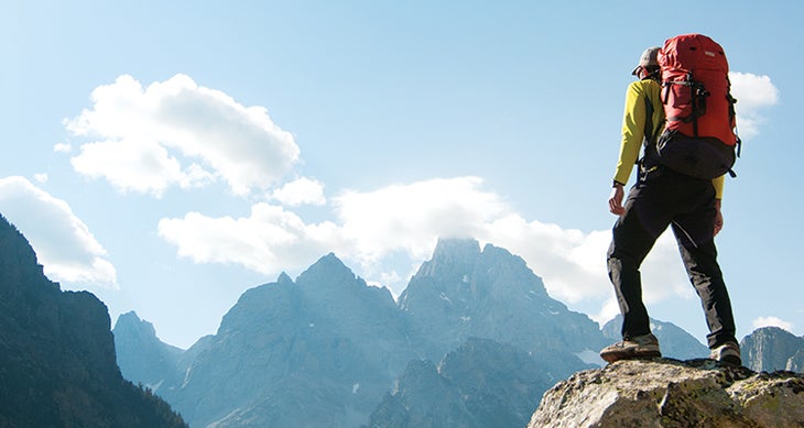
Editor’s Note: How do you pick the 100 best miles in America’s national parks? We and writer Elisabeth Kwak-Hefferan took on that task in 2015, and we think the list we came up with still stands up. Today, we’re resharing it—updated with new permit regulations—to help you plan your best hiking season ever. Fun fact: When I did the math on this list, I discovered we cheated by sneaking in an extra mile, bringing up the total to 101. Turns out that no matter how much you hike in the national parks, there’s always another incredible trail just waiting to tempt you. —Adam Roy, Executive Editor
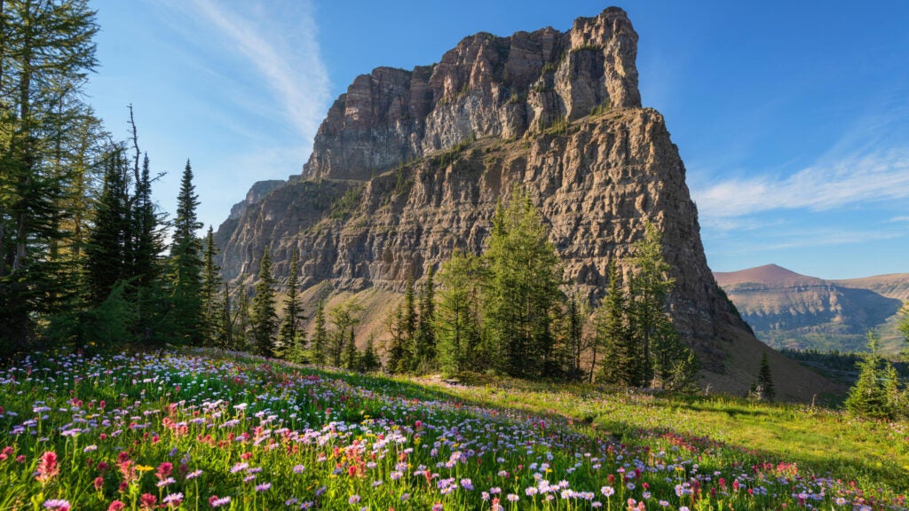
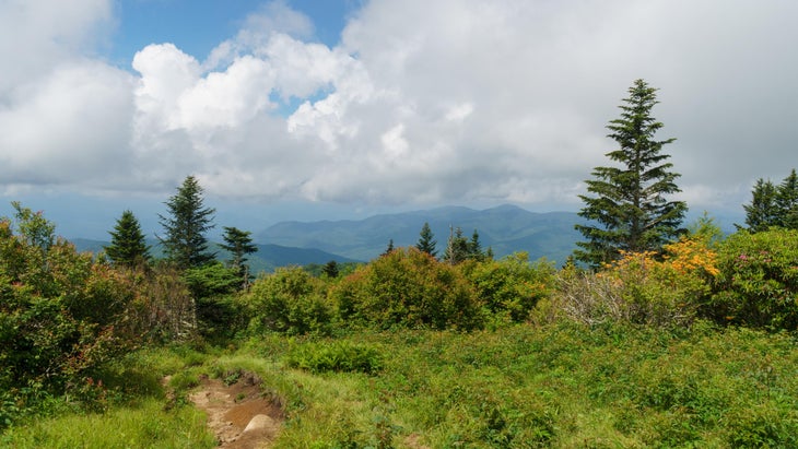
With a wink and a nod to the Grand Canyon’s endless curves, Glacier’s spiky summits, and Yellowstone’s steaming geyser basins, Yosemite is the beauty queen of the national parks.
No other park can quite match the granite domes, ground-shaking waterfalls, and massive sequoia groves for sheer scenic power. And no other stretch of trail better captures it all than these miles from Tuolumne Meadows, over a classic summit, and past a pair of cascades.
The highlights start rolling after the first 3.5 miles on the John Muir Trail, when you reach Upper and Lower Cathedral Lakes in an alpine bowl under 10,940-foot Cathedral Peak. Rejoin the JMT (via a short spur) and turn south toward Cathedral Pass to Sunrise High Sierra Camp. Turn north on the Sunrise Trail to Sunrise Lakes, a clutch of tarns with white granite “beaches,” then hit a trail junction and go south on the Clouds Rest Trail.
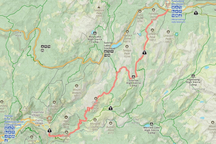
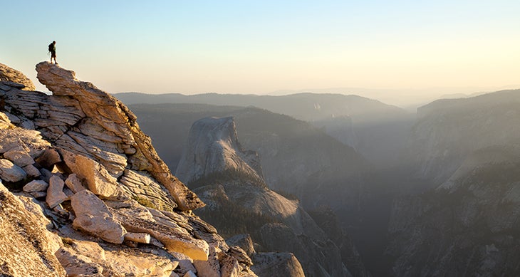
The trail drops through a small, forested canyon; look for sheltered campsites about 13 miles in. Once past the narrow, rocky ridge, you’ll be standing on a 9,926-foot summit, looking down on Half Dome—plus Tenaya Canyon, Yosemite Falls, El Capitan, and the Clark Range. You may not technically be on top of the world, but you’ll feel like it.
Descend Clouds Rest’s southern side to rejoin the JMT. Take it to Little Yosemite Valley, where hordes of Half Dome hopefuls gather for a shot at peak views similar to the ones you just earned (join them if your backcountry permit allows it). You’ll have company on the Mist Trail as you descend beside 594-foot Nevada Fall and 317-foot Vernal Fall to Happy Isles, but you won’t blame anyone for wanting a look at some of America’s finest miles.
Trailhead 37.873323, -119.382854
Total hike 24 miles
Camping In designated zones; enter the permit lottery 24 weeks ahead ($10 + $5/person), try for a remaining permit 7 days before your trip, or try for a walk-in permit (good luck).
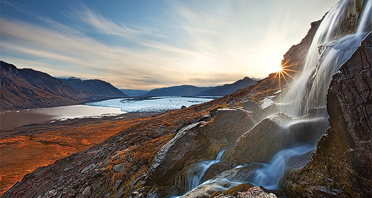
How did we zero in on just 10 miles in the 8 million acres encompassed by Alaska’s park lands? It’s partly a technicality: Actual trails are hard to come by in this wild state. But mostly, it’s because this chunk of tundra where the Wrangell and St. Elias Ranges meet is raw Alaska at its finest (and in truth, the aptly named Goat Trail is still only sort of a path).
Reaching this primo stretch requires a bush plane flight to the Wolverine airstrip and miles of forest and canyon hiking, plus several dicey river crossings, but the fun really begins when you hit the infamous Goat Trail. The route follows a path worn by Dall sheep and picks its way across a ketchup- and mustard-striped cliff band of crumbly limestone for a mile (scout carefully for the real trail—following one of the hoof-made spurs too far can cliff you out). Once across, follow the Chitistone River northeast and spill out onto the spongy tundra of Chitistone Pass. Here, forget-me-nots and moss campion bloom under nameless, glacier-crusted peaks and, on a clear day, the views stretch deep into the colossal University Range. As you crest the northern side of the 3-mile-long pass, the Russell Glacier comes into view like a 20-mile-long, 2-mile-wide tongue unfurling from 16,421-foot Mt. Bona. From there, you’ll drop another 2 miles to Skolai Pass. Keep your eyes peeled for grizzlies, caribou herds, and the occasional wolf before meeting your plane at Skolai Lake. Congratulations—you’ve just punched your Alaska hiking card in a big, big way.
Trailhead 61.508746, -142.299173
Total hike 16 miles (4 to 7 days).
Camping Allowed throughout route; no permit required
Think the view of the mighty Tetons is impressive from the park road? Wait ’til you see them from the backcountry: The Teton Crest Trail runs through the scraggy alpine zone west of the summits, dishing out vistas that somehow make 12,325-foot Teewinot, 12,804-foot Middle Teton, 12,928-foot Mt. Owen, and 13,700-foot Grand Teton look even bigger. That’s especially true for this 9-mile section of the 39-mile trail, which tracks through the heart of the range.
After trekking up Paintbrush Canyon (no slouch in the scenery department, either), you’ll get your first slap-in-the-face views of the Grand from 10,720-foot Paintbrush Divide. Mt. Owen and Teewinot explode into view as you link up with the Teton Crest Trail and drop 1,000 feet over a mile to Lake Solitude (see page 112), a wildflower heaven in summer. The peaks stay front and center as you wind south through the evergreen forests of North Fork Cascade Canyon and up the switchbacks in South Fork Cascade Canyon to Schoolroom Glacier, a remnant ice field next to a teal-colored lake. Press on to 10,338-foot Hurricane Pass, where the vistas reach their climax. In all honesty, you haven’t really seen the full glory of the Tetons ’til you see them from here.
Trailhead 43.788255, -110.7368792
Total hike 32.6 miles (loop via Cascade Canyon Trail)
Camping Allowed in the North Fork Cascade and South Fork Cascade Camping Zones; request permits starting in January ($20 per permit, plus $7 per person, per night)
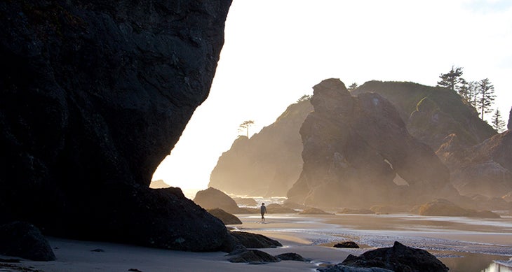
With due respect to the sugar-sand beaches of the world, we like our coastal treks wild, rugged, and with a chance of rain.
You could parachute into any of the park’s 73 miles of coastline and have the trip of a lifetime, but the very northern tip of the beach gets our nod for its density of sea-sculpted rocks, gritty scrambling, and the oasis of Shi Shi Beach.
After 2 miles of Sitka spruce and Western hemlock forest on the Shi Shi Beach Trail, shimmy down a 50-foot bluff to pop out on Shi Shi Beach, with wide swaths of sand, pyramidal sea stacks, and tide pools rich in starfish and hermit crabs.
Point of the Arches, at the beach’s southern boundary, offers a mile-long parade of pinnacles, boulders, and precariously balanced sea arches. For the next 2 miles, the Pacific swallows the beach at several vertical headlands during high tide (carry a tide table and round them only when the tide ebbs).
After the last crossing (around mile 7), the route widens into 4 miles of driftwood-scattered beach end-capped by the Ozette River, a shin-deep ford that swells to an impassable flood at high tide. Once across, stroll 2 miles to the turnaround at Cape Alava.
Trailhead 48.319167, -124.675556
Total hike 30 miles (out and back).
Camping Allowed at 7 designated sites (can’t go wrong); reserve permits for sites south of Point of the Arches starting April 15 ($6 + $8/person/night). Also requires a $20 Makah Recreation Pass)
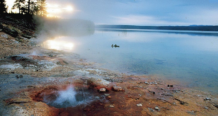
Frontcountry geyser basins are cool. But backcountry geyser basins, where no boardwalks or crowds interrupt the steaming, bubbling, bursting landscape, are where the earth really comes alive. Getting to Shoshone’s geysers and hot springs is half the fun: You’ll hike deep into a wilderness filled with grizzlies and bison, crossing the Continental Divide at 8,010-foot Grants Pass before dropping to the basin on the edge of Shoshone Lake (or paddle there). This ain’t no Old Faithful area: You’ll experience Yellowstone’s thermal zones as they were in the 1800s. Step carefully.
Trailhead 44.418486, -110.805745
Total miles 34 (out and back)
Camping Allowed at 5 designated sites en route. Join lottery starting March 1 ($10 + $5 per person, per night) or try for a walk-in permit.
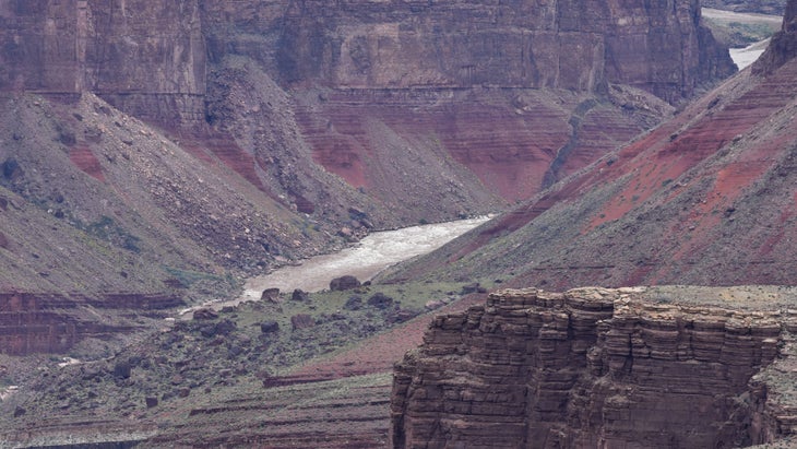
If it were possible to take every inch of the 277-mile-long, mile-deep Grand Canyon and distill it to its essence, the result would look a lot like the five-day Escalante Route. And if you whittled that down to the ab-so-lute supreme slice of trail in the whole of the Grand, you’d have these 9 miles packed with Colorado River beach campsites, slot canyons, cliffy scrambles, and view after epic view across the Grand’s sunset-colored temples and buttes.
You’ll be two days into the Escalante Route before you hit this stretch starting at Cardenas Camp, a sandy beach along the chocolate-milky Colorado River. From there, hoof it up to the Unkar Overlook, a short spur to a 1,000-foot cliff with views of the class 4-7 Unkar Rapid and across the river to the rectangular outlines of several ancient Puebloan ruins. Continue west, skirting Escalante Creek to the top of Seventyfive Mile Canyon, a squeeze of a slot that winds beneath 300-foot-tall quartzite rock walls and requires a 30-foot downclimb (use a rope to lower packs) to rejoin the river just upstream of Nevills Rapid.
After a night next to the waves, follow a series of ledges along the river to the mouth of Papago Canyon, where you’ll need your hands and feet to haul yourself up a 35-foot series of rock balconies to a ridge. The trail then winds back down a gully choked with boulders to the river at Red Canyon, a sandy campsite with views of Hance Rapid. Climb out through layers of geologic time back to the rim via the Tonto and Grandview Trails, or book it straight out of the canyon on the 6.5-mile New Hance Trail.
Trailhead 36.071683, -111.831825
Total hike 33 miles (shuttle to Grandview trailhead from South Rim visitor center)
Camping Anywhere in designated zones; request permits starting four months in advance ($10 + $12-15 per person, per night).
Smokies’ rangers like to boast that hiking in the park is like traveling from North Carolina to Maine: In one trip, you get Southern staples like blooming tulip trees and lush river valleys at the lower elevations, upper Appalachian hardwood hollows and lacy waterfalls in the mid-ranges, and the crisp spruce-Fraser fir forests of New England along its 6,000-foot-plus backbone. This 8-mile section lets you make the journey in a weekend.
Start with a quick climb to the summit observatory on Tennessee’s high point, Clingmans Dome, then flee the crowds via the Forney Ridge Trail, passing through boreal forest to 5,906-foot Andrews Bald, where the best miles begin. From this grassy vantage, vistas stretch over Fontana Lake and the Smokies’ wrinkled ridges. Backtrack slightly to the Forney Creek Trail and drop to the creek, your constant companion for the rest of the hike.
Follow it downstream to one of the best campsites in the entire park, #68, which sits at the base of Forney Creek Cascade, a 40-foot slab waterfall. Take a dip in the birch-shaded pool above the site even if you don’t stay the night. The next bit features a wetter, greener forest with several creek crossings (check water levels), past campsite #69. You’ll drop 3,800 feet by the time you splash through the final three fords to the junction of Forney and Jonas Creeks and campsite #70, making your day part Maine, part southern Appalachia, and 100 percent Smokies magic.
Trailhead 35.562988, -83.498540
Total hike 18.6 miles (out and back) or 20.6 (loop via Springhouse Branch and Forney Ridge Trails).
Camping Allowed at 3 designated sites. Request permits up to 30 days ahead ($8 per person, per night).
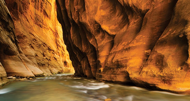
It’s the sweetest mile in the best slot canyon in America—maybe the world—even if it’s not a trail, per se. Rippled red rocks reaching hundreds of feet above you echo the riffled Virgin River washing around your body. To hike it is to be swallowed by the canyon itself, in the best possible way. Nowhere is this feeling more apparent than when the walls pinch to 20 feet wide in the mile-long Wall Street corridor at the mouth of the Orderville Canyon (Narrows mile 2.7). Consider it the absolute zenith of a trek that’s already in the upper echelon of the parks experience.
Trailhead 37.284717, -112.947975 (for the bottom-up version)
Total hike 7.4 miles (bottom-up, out and back) or 16 (point-to-point through the entire Narrows)
Camping Request permits for hikes on the 5th day of the month preceding your trip ($20 plus $7 per person, per night for overnight trips, or $10 per person for day trips) or try for a last-minute walk-in permit (same price)

There are no disappointing trails in Glacier. But to see the place at the apex of its glory—snow-scrubbed peaks, precipitous cliffs, meadows flush with Skittle-colored blooms and gigantic waterfalls—head to the park’s remote northwestern corner. Climb from the shores of Bowman Lake and skirt the vertical headwall of Hole in the Wall, a 1,200-foot hanging glacier valley. You’ll wind up in the snowfield-speckled high country and the cherry on top of the trip: the alpine zone connecting 6,255-foot Brown Pass and 7,478-foot Boulder Pass. Press on to the latter, a 2-mile-long gap dotted with tiny, bright blue pools and eastern views of Thunderbird Mountain, Mt. Chapman, and back down to Hole in the Wall.
Trailhead 48.888586, -114.200907
Total hike 38.8 miles (out and back).
Camping Allowed at Hole in the Wall and two other designated sites on the Bowman Lake Trail. Request permits through lottery starting March 15 ($10 plus $7 per person, per night) or get a first-come, first-serve permit on recreation.gov starting May 1.

Why simply hike a mountain when you can climb it? With ladders, iron rungs, and slender rock ridges to help you hoist yourself 1,000 hair-raising feet, this route is more like a jungle gym than a trail. Luckily, you don’t need special gear to scale Champlain Mountain on the Precipice Trail, but a strong grip and nerves of steel wouldn’t hurt. For the effort, you’ll earn big views over an Atlantic coast scattered with chunky granite islands and riddled with watery inlets. Bonus: A spiking heart rate and big dose of adrenaline come free with the terrain.
Trailhead 44.349479, -68.188075
Total hike 2.6 miles (loop via Champlain North Ridge and Orange & Black Trails)
Take everything we love about Upper Midwest hiking—serene forests, rocky bluffs, the soundtrack of howling wolves and lilting loons, and above all, those glorious lakes—turn it up to 11, and you have Isle Royale. The island’s charms are in full force on its northeastern tip, where the trail hugs the shoreline for constant lake views. It’s here, where dry land’s victory over the water’s countless incursions of bays, inlets, and waves never seems totally assured, that you’ll best appreciate the drama of this rugged refuge.
Start on the Stoll Memorial Trail and hike east through the spruce-fir woods to the stony finger of Scoville Point for horizon-gazing across Lake Superior. Look for moose on the return hike along Tobin Harbor, a sheltered cove sprinkled with evergreen-furred islands of its own.
Trailhead 48.103765, -88.567016
Total hike 4 miles
Camping None on this route
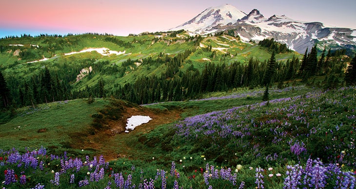
There are all other mountains in the Lower 48, and then there’s Mt. Rainier. A few other peaks are taller, sure, but no single summit can beat this 14,409-foot volcano, the jewel of Washington’s Cascade Range, for top-to-bottom immensity. And with its necklace of showy wildflowers, glacier-draped crown, and waterfall after roaring waterfall spilling from its shoulders, we’ll go ahead and say it—it’s the prettiest one, too. The 93-mile Wonderland Trail that rings the peak serves up a full buffet of Mt. Rainier’s beauty, but if you want to skip straight to dessert, head to this dayhikeable section on the peak’s northeastern flank.
Start by ascending through the Fryingpan Creek Valley, popping ripe huckleberries into your mouth along the way if it’s late summer, until you rise above the trees to reach-out-and-touch-it views of The Mountain. At mile 4, hit Summerland, an open meadow doused with gentian, subalpine buttercups, aster, and dozens more summer blossoms. Hike another 2 miles through rocky and snowy terrain to top out on Panhandle Gap—at 6,800 feet, the Wonderland’s high point—for views of the enormous Fryingpan Glacier. You’ll stay high even as you descend from there into the subalpine meadows above Ohanapecosh Park, passing a massive cirque streaked with a dozen waterfalls, before reaching yet another wildflower-dazzled basin at Indian Bar.
Trailhead 46.920662, -121.883993
Total hike 18 miles (out and back)
Camping Allowed at Summerland and Indian Bar; enter the lottery in February ($26) or try for a walk-in permit ($6)
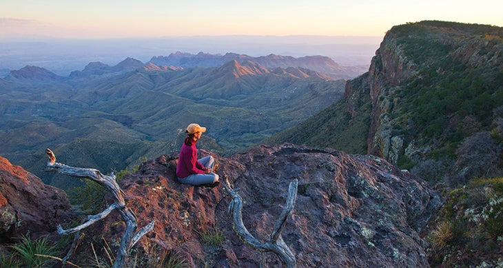
From the desert surrounding the Chisos Mountains, the South Rim lords above the scrublands like a fortress, its cliffs sheer enough to turn back an invading army. And from on top? “It’s one of the great views of the national park system,” says former Big Bend Chief of Interpretation David Elkowitz. “It’s up to a 2,000-foot drop, and if you look out on a clear day, you can see the Rio Grande and the mountains of Mexico. There’s very little made by man in that view.” And the soaring terrain near the park’s center forms a sky island, where wetter, cooler conditions shelter plants and animals you won’t find anywhere else in Big Bend—such as Douglas fir, Arizona cypress, and the Sierra del Carmen whitetail deer.
Getting to the most dramatic views means hiking past bulbous rock spires on the Pinnacles Trail and through the lush ecosystem of Boot Canyon to top out on the Northeast Rim. Wind past spiky cacti and agave to your first big vistas of the rolling hills below, then connect to the Southeast Rim Trail for a clifftop stroll with views extending to Mexico’s Sierra del Carmen mountains. The scene changes again on the Southwest Rim Trail, where you’ll see the volcanic landscape of the Sierra Quemada and the twin Mule Ears peaks. Your island may be ringed by high-in-the-sky panoramas, not water, but the result is the same: You’ll want to dig your toes into the sand and stay awhile.
Trailhead 29.229368, -103.295453
Total hike 14.6 miles (loop via Laguna Meadows Trail)
Camping Allowed at 12 designated sites along the rim. Request permits ($10), in person only, at any visitor center up to 24 hours before your trip.
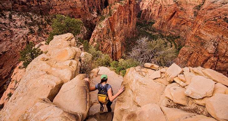
Maybe they should have called this spot the Zion Narrows: the 400-foot, chain-assisted final push up this classic summit crosses an exposed rock fin just a few feet wide with 1,000-foot drop-offs on either side. The scramble up is every bit as thrilling as the eagle-eye view over Zion Canyon you get from the crest of 5,790-foot Angels Landing. It’s hard to get this popular view to yourself, but set off at dawn for the best chance.
Trailhead 37.259282, -112.951298
Total hike 5 miles (out and back)
Permit Enter the seasonal lottery starting on March 1 ($3 per person), or apply the day before starting at midnight.
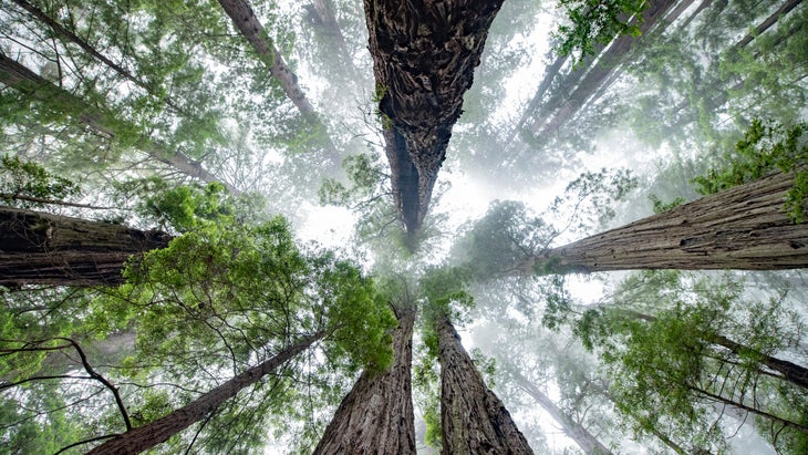
Just getting to the secret sanctuary known as the Emerald Mile qualifies as a life-list hike: You’ll wander among the giants in Tall Trees Grove, a dense stand of immense, 300-foot-plus redwoods. But once you shake the tourists by hiking south along the wide gravel bar of Redwood Creek, the magic really begins: “You get the feeling you’re in a primeval forest in there,” says ranger Jim Wheeler. Countless old-growth redwoods and Douglas firs line a deep gorge, building a natural tunnel that will keep your eyes endlessly drawn up, up, up.
Trailhead 41.207450, -124.012202
Total hike 7 miles (out and back) or 4.5 miles (loop via Emerald Ridge Trail)
Permit Make a reservation (free) and get the combination to Tall Trees Access Road
Camping Allowed along Redwood Creek at least .25 mile from Tall Trees Grove. Grab a free permit at any park visitor center.
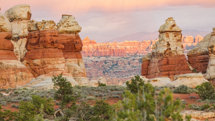
The Maze District is this desert paradise’s most remote corner, and there’s no better introduction to the area than this rare maintained trail from the Colorado River to a temple of sandstone spires. From the Spanish Bottom beach, take the Spanish Bottom Trail, stair-stepping more than 1,000 feet in elevation in less than a mile, to the Doll House’s hundred-foot rock pinnacles. Short loops from here lead to Ancient Puebloan granaries and an overlook across the verdant Surprise Valley—if you can tear yourself away from the twisting playground within.
Trailhead 38.158080, -109.934478 (3.5 miles south of the confluence of the Colorado and Green rivers; accessible via raft, canoe, jet boat)
Total hike 4.3 miles round-trip
Camping Allowed at Spanish Bottom with river permit ($36, reserve up to 4 months before the beginning of your season) or on the rim with a backpacking permit.
From 2024
