


Back in 2007, I watched an endemic island fox lope along an old sheep trail on Santa Cruz Island, the largest of the five isles in Channel Islands National Park, and it was an easy decision to follow it. We were on a remote trail, and I couldn’t pass up a chance to watch wildlife in action.
Today that far-flung single track is the Montañon Ridge Loop Trail, a 10-mile round trip ramble on one of the least-visited national parks in the country. Despite being added to the Channel Islands National Park map in 2018, it’s extremely rare to see anyone hiking the Montañon Ridge today.
However, you could say the same about most of the trails on the Santa Barbara, Anacapa, Santa Cruz, Santa Rosa, and San Miguel islands that encompass the Channel Islands as a whole. Despite being only 60 miles west of the Los Angeles megalopolis, the Channel Islands offer unique solitude. And stunning biodiversity—the islands are also known as the “Galápagos Islands of the north.”
These islands offer a slew of trails that lead to nameless coves, deserted beaches, towering cliffs, unique forests, and incredible wildlife surrounded by the California Current, teeming kelp forests, and toothy sea caves.
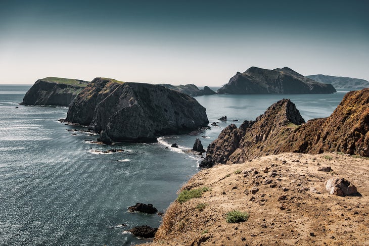
If you only have time for one hike on one island, then Inspiration Point should be it. Only 11 miles away from the mainland, Anacapa is the closest island to Los Angeles. After reaching the landing cove and climbing 250 steps to the top of the isle, hiking is easy across an ancient marine terrace to Inspiration Point.
You’ll wade through throngs of raucous western gulls, California brown pelicans, and island flora while hiking west to arguably one of the prettiest (and most Inspirational) vistas across the entire northern chain. It really doesn’t matter what the weather is like; standing on the edge of East Anacapa Island and gazing across to Middle and West Anacapa Islands and beyond to the southeast fringe of Santa Cruz Island is mesmerizing.
This is the only opportunity to hike from national park lands into The Nature Conservancy (TNC) property. TNC owns 76 percent of Santa Cruz Island and CINP owns the remaining 24 percent, the southeast end.
This out-and-back hike begins and ends at Prisoners Harbor. After disembarking the Island Packers ferry, you’ll climb and descend into shaded side canyons choked with island flora such as island oak trees, manzanita, island hazardia, and island buckwheat. The seasonal drainages spill into hidden coves and the Pacific Ocean. This is also one of the best places to see the endemic island fox and island scrub jay, both species found nowhere else on earth.
At the turnaround of this hike is Tinkers Cove and Pelican Bay. Tinkers is a great lunch spot and an ideal place to jump into the water. Pelican Bay is a popular place for private boaters. There are also remnants of a resort formerly belonging to Ira and Margaret Eaton, a married couple who helped shape the history of Pelican Harbor by providing boat transportation and housing for early Channel Islands tourists. Popular among fishermen and Hollywood elites in the early 1900s, this resort still clings to the ancient, weather-beaten volcanic crags of Pelican Bay.
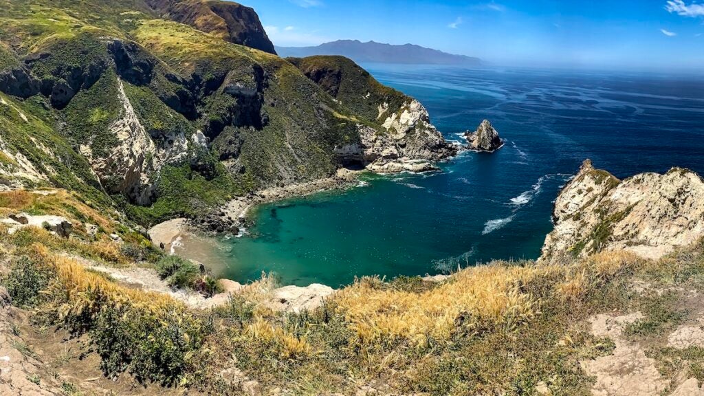
This hike offers some of the best views of the most biodiverse island off the California coast. From the pier at Scorpion Anchorage and for the first 2 miles, the trail hugs the edge of the cliffline out to Cavern Point and Potato Harbor, where you’ll eventually see the sign leading to Montañon Ridge. While ascending, hikers rise above Potato Harbor, Coche Point, and Chinese Harbor as California sea lions bellow in the distance. The entire north side of Santa Cruz Island is also visible before reaching a narrow, nameless ridgeline that leads easterly toward epic vistas of the Anacapa Passage and Anacapa Island. On clear days while descending the ridge, three other islands are visible in the southern chain: Santa Barbara, Santa Catalina, and San Nicolas.
As the trail descends back toward Scorpion Anchorage and the shimmering Santa Barbara Channel, keep an eye out for more island foxes. There are approximately 2,900 of them running wild across the windswept island.
This is an ideal dayhike if all you have is one day on Santa Rosa. The trailhead to this easy loop hike is right next to the campground in Water Canyon. After ascending above the campground atop a sweeping marine terrace, the trail opens into a narrow canyon highly concentrated with island flora. Wind-blown island oaks cling to the canyon walls, fragrant silver lupine wafts above the canyon, and willowy island buckwheat sways with the afternoon northwest winds. It keeps the birds happy; birdsong is prevalent throughout the canyon. Bewick’s wrens, Northern Channel Islands loggerhead shrikes, spotted towhees, and house finches are busy along this trail. Hikers might also have to share the narrow path with an occasional island fox. The trail leads to a seasonal creek that flows from the southwest eventually running along the backside of the Vail and Vickers historic ranch site and out to Bechers Bay.
You can spot the famous Torrey pine forest on the approach from the Island Packer boat. The forest hovers above massive Bechers Bay and wind-whipped Santa Cruz Passage. From the pier, it’s an easy walk atop a marine terrace past the historic Vail and Vickers Ranch. From there, hikers head southeast passing a dirt airstrip and Water Canyon as the forest comes into view again. There’s only one other Torrey pine forest in the world and it’s in San Diego at the Torrey Pines State Natural Reserve. This forest, though, is dense. Their pinecones are enormous, and their dense branches and trunks occasionally grow thick enought to block out the sun. It’s also a good place to hide from the strong northwesterly winds that perpetually howl over the island. Once you reach the forest, turn around on your hike and return to Bechers Bay.
Lobo Canyon is a great example of how wind and water sculpted all the canyons in the national park for thousands of years. The canyon is located on the north side of the island, where a year-round stream flows through the winding sandstone ravine all the way to a splendid pearl-white beach. Tiny island fox prints crisscross the steady stream amongst a chorus of Pacific green tree frogs. The beach itself is one of the many oases surrounding Santa Rosa Island. It separates the canyon and the ocean, and it’s a great place to swim before hiking back to Bechers Bay.
All hikes on San Miguel Island are ranger-led. The island was once a bombing range during World War II, so there could still be live ordnances on the windswept isle. Visitation to this island is seasonal. Due to strong northwest winds and swells, the national park offers access from June through October.
It’s worth it, though, because the hiking across San Miguel is remarkable. To hike any of its trails requires camping on the island, and backpackers need to bring all their supplies with them. The island is remote and feels far away, and once at the overlook to Harris Point, it can feel even further. Starting from the ranger station, the trail winds through what feels like a botanical garden: The island receives most of its moisture from fog drip, so island poppies, buckwheat, mallow, and dudleya bloom beyond spring.
Harris Point faces directly toward the northwest where wind and swell hammer away at its rocky, wave-sculpted appendage. However, it doesn’t seem to deter seafaring birds such as common murres nesting within its volcanic crags.
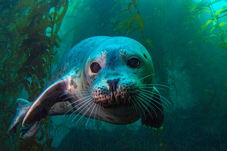
If wildlife is what you’re looking for, then Point Bennett will not disappoint. Made up of rock outcroppings smothered in seabird guano and gritty, wind-groomed beaches, Point Bennett houses the largest seal and sea lion rookery in the world. Six different species of pinnipeds haul out, breed and pup at the northwesternmost point in the national park. Population numbers are astounding; somewhere between 30,000 to 50,000 animals thrive there, surrounded by the California Current. It’s a potpourri of wildlife sights, sounds, and smells.
The out-and-back hike begins at the ranger station traversing over San Miguel Hill and Green Mountain. Between those two peaks is the petrified Caliche Forest. Island foxes also abound but are shier than on the other isles. On San Miguel Island they are more visible at dawn and dusk as they dart back and forth beneath the low-lying island vegetation.
Once at the Point Bennett overlook, the sheer amount of pinnipeds is astounding. The trail descends to the sand dunes to watch one the world’s greatest wildlife spectacles unfold. Pups are nursing, males are battling over females and precious territories, and seals and sea lions bodysurfing onto a steep berm is always entertaining.
For camping reservations go to recreation.gov. For information about Channel Islands National Park go to nps.gov/chis. For boat transportation go to islandpackers.com. For sea cave kayaking go to islandkayaking.com and explorechannelislands.com.
From 2023
