


There are many things that motivate hikers to chase adventure. For some of us, a good hike means venturing out somewhere new. For others, nothing beats the serenity of a familiar place, or even a mountain you’ve hiked monthly for 15 years. If you lack motivation to get out, though, it’s hard to beat a good bucket list.
Whether it’s hiking one hundred miles in one go, traveling to a new country, or seeking out rare wildlife, chasing a big goal can jumpstart your inspiration and get you planning your next trip. Get your 2024 started right with our “bucket quests.” These dream itineraries will test your limits, drop you in far-flung destinations, and leave you wanting more.
The Hike: Sunshine Coast Trail,Powell River, British Columbia
You can walk 100 miles just about anywhere, but to do it in style, head to Powell River, British Columbia in search of the Sunshine Coast Trail. This 111-mile trail, from Sarah Point to Saltery Bay, traces its ways across the coast through dense forests and past fjords, lakes, and peaks. It’s approachable enough to be someone’s first long-distance hike, but also has enough beauty and grandeur to make experienced thru-hikers weak in the knees. From Tin Hat Hut, the trail’s halfway point, you’ll drink in 360-degree views of no less than 32 lakes and endless coastal mountain ridges.
Despite its length, planning a trip on the Sunshine Coast Trail isn’t that daunting. There are 14 huts along the way—enough that you can hike at a leisurely 10-mile-a-day pace and still count on having a roof over your head each night—and many are insulated and have wood- or pellet-burning stoves. They’re also free of charge, and tent camping is plentiful if that’s your preference. Resupply is simple, as is finding an exit point if you need to end your hike early. Perhaps the biggest comfort of all is that the Sunshine Coast isn’t considered grizzly bear habitat. Though backpackers have occasionally spotted grizzlies in the region, sightings are few and far between.
That said, hiking the trail isn’t a walk in the park. You’ll climb about 25,000 feet over the course of the journey, and steep ascents and rocky descents are common. Despite the name, the Sunshine Coast isn’t always bright and cheery—the region averages about 67 inches of rain a year—and even the sunnier summer months can be pretty wet. And while grizzlies might not be a top concern, there are other megafauna of note, including black bears, mountain lions, and wolves.
For most hikers, transportation to and from the trail will likely be the hardest part of the journey. Though the southern terminus of the Sunshine Coast trail is only 90 miles from Vancouver, it feels a world apart. That’s because it is—imposing fjords and mountains prevent any roads from connecting the region to the outside world. Getting to Powell River means taking a plane or two ferry rides. From there, most hikers hike north to south, starting at Sarah Point. It’s possible to get to your starting point with a high-clearance vehicle, but you can also get a shuttle from Powell River. At the southern terminus In Saltery Bay, you’ll have to take another ferry to find your way back home.
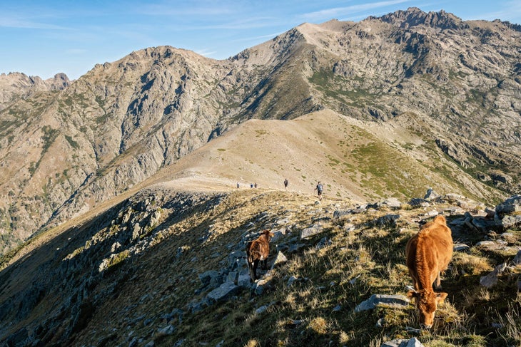
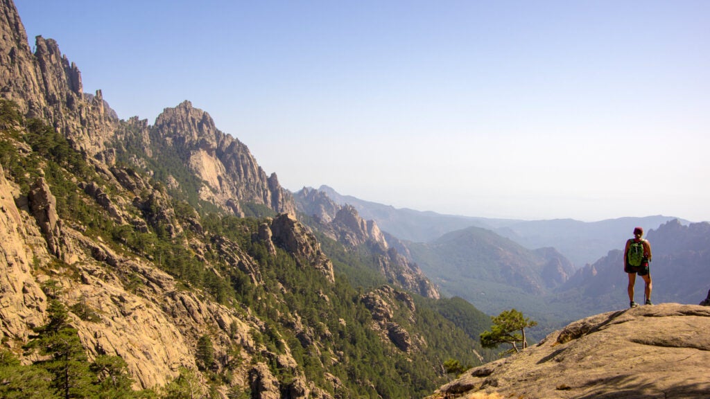
The Hike: GR20, Corsica, France
Commonly called the toughest hike in Europe, the GR20 is lengthy—like the Sunshine Coast Trail, it’s over 100 miles long. But according to hikers who have trekked the whole thing, it’s one of the most beautiful hikes in the world. The most unique feature is its location, traversing the length of the Mediterranean island of Corsica.
As for its reputation as Europe’s toughest hike? That comes down to terrain and weather. Often rugged and exposed, the route traces the spine of the island on rocky peaks and ridgelines that will test your quads and ankles. Weather can arrive fast and fierce; plan on at least a few days of wiggle room to wait out the storms, which can be dangerous at high elevations. Though it’s impossible to nail down an exact statistic, the GR-20 is rumored to have a dropout rate of about 75 percent. That’s roughly the same rate as the Appalachian Trail, which is about twenty times longer.
Setting aside the weather and terrain, many of the specifics of the trail are downright cushy. As one of Europe’s GR or “Grande Randonnée” routes, it’s well-signed and marked with the traditional red-and-white blazes that grace all GR trails. Dangerous animals are non-existent, unless you count curious livestock. There are enough huts that you could hike the entire trail without a tent, and many people opt for that method. Our recommendation? Stop at the refuges for breaks and meals (and the occasional hot shower and flush toilet), but pitch a tent at night: While the refuges are a fun social experience, they’re also crowded, noisy, and require booking in advance. Staying in a tent is peaceful and stress-free in comparison.
Still, the GR20 is a popular trail, and it’s worth embracing that reality. Get ready for crowds (especially in July and August), bookend the hike with a few extra days to explore the coast, and learn a few French phrases to make the most of the experience.

The Hike: Susquehannock Trail, Pennsylvania
If you want to get as far from a road as possible, you have a few options. One is to head to Alaska, where huge stretches of roadless wilderness are common. Another is to head west: In the Lower 48, one of the most remote regions is actually in the very popular Yellowstone National Park. There, if you hike the entirety of the 34-mile Thorofare Trail, you’ll find yourself about 20 miles from even the nearest dirt road.
But what about on the East Coast, where the majority of Americans actually live? To find solitude here, head to northern Pennsylvania and explore the Susquehannock Trail, an 85-mile footpath that’s cherished by locals and unknown to almost everyone else.
Rather than one uninterrupted path, the Susquehannock Trail is a collection of 63 separate trails, the majority of which were cleared in the 1930s by Civilian Conservation Corps crews. The entire trail is one of quiet and understated beauty, heavy on stands of towering hemlocks and low on otherhikers. But there’s one stretch that stands out for its stillness—the Hammersley Wild Area.
Though it’s administered by the state, the Hammersley shares an ethos with federally designated wilderness: It’s roadless and off-limits to all forms of motorized and mechanized equipment, from snowmobiles to mountain bikes. By the numbers, Hammersley doesn’t seem like a great expanse of wilderness, especially compared to the Western states. At about 30,000 acres, it’s just a small blip of untrammeled terrain on the otherwise crowded East Coast, and you’ll never get more than about six miles from a road. But if you camp in one the wildfire-cleared meadows here, the still night and view of the Milky Way (Hammersley also has some of the darkest night skies on the East Coast) will be enough to convince you that you’re truly in the wild.
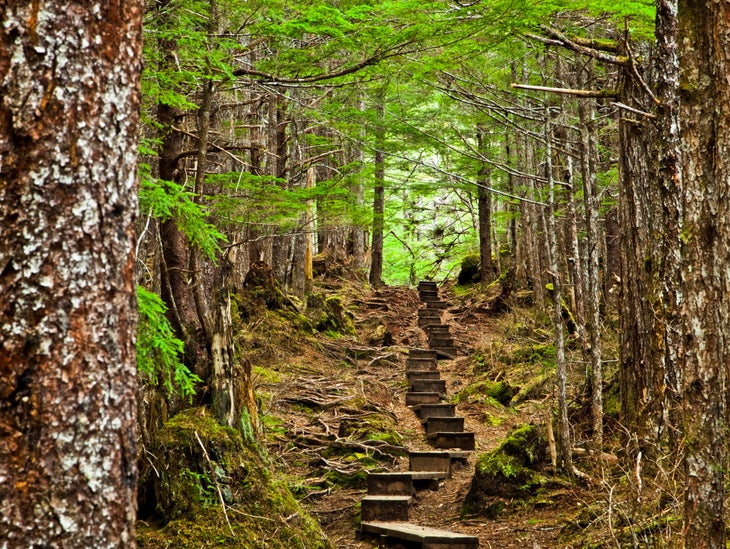
The Hike: Gavan Hill Trail, Sitka, Alaska
Exploring the Tongass National Forest is on many people’s bucket lists, and for good reason. At 17 million acres, it’s the biggest expanse in the National Forest system, as well as the largest temperate rainforest on the planet. Experiencing every corner of the Tongass is nigh impossible, but hiking through a tiny sliver of it isn’t too hard—the toughest part will be finding your way to the island town of Sitka. From there, the Gavan Hill Trail will take you into the dense, lush forest before leading you above treeline so you can grasp the size of the landscape. Best of all, it’s within walking distance of downtown.
From town, you’ll begin this 12-mile out-and-back hike by crossing a muskeg (that’s Alaskan for peat bog) before ascending Gavan Hill itself. The trail is a marvel of craftsmanship, with thousands of feet of boardwalk, staircases, and bridges engineered to help hikers cross marshy ground and ascend steep slopes. But the forest it winds through is the real highlight—ancient and primeval, strewn with mosses and lichens, and dominated by sitka spruce, cedar, and alder.
When you gain the ridgeline after more than 2,000 feet of climbing, the forest gives way to expansive views in every direction. To the east are the peaks known as the Sisters (also hikeable if you’re up for a routefinding mission through muddy bogs and choking underbrush), while Mt. Edgecumbe, an iconic volcano on the opposite side of Sitka Sound, dominates the view westward. Eventually, the Gavan Hill ridgeline leads to the summit, where Gavan/Harbor Shelter offers some respite in bad weather and no-frills accommodation on a first-come, first-served basis.
While the Gavan Hill Trail is an easy-access day hike, it’s important not to underestimate it. The damp forest floor makes for slick footing, and slips and falls are common. And although Gavan Hill isn’t exactly a mountain, it shares the fickle weather that hikers from the Lower 48 associate with tall peaks. The weather can change quickly, and Sitka Search and Rescue says that Gavan Hill is a hotspot for emergency evacuations.
The Hike: Creamery Meadow Loop, Big Sur, California
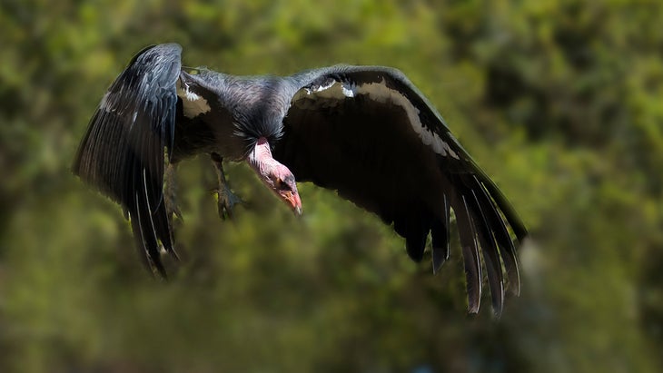
Few endangered species have a survival story as dramatic—or inspiring—as the California condor. After facing years of habitat degradation, poaching, and exposure to agricultural chemicals, by 1987 the number of condors living in the wild had dropped to just 27. In a last-ditch effort, conservationists managed to capture the last wild birds, and began captive breeding programs in San Diego and Los Angeles. By 1991, condors were reintroduced in the wild, and numbers have been climbing ever since.
Today, condors have been successfully reintroduced in a number of places across the country, including the Grand Canyon and Zion National Park. One of the most scenic locations to spot America’s largest avian species? The dramatic stretch of California coastline known as Big Sur. To see one for yourself, head to Andrew Molera State Park, and take on an eight-mile dayhike along coastal cliffs, ridgelines, and beaches.
The loop isn’t a single trail, but a combination of four: the Creamery Meadow Trail, Ridge Trail, Panorama Trail, and Bluffs Trail. Hike this lollipop loop clockwise to tackle the climbs (totalling about 1,400 feet of gain) early, and watch out for poison oak, which is abundant on the California coast. To start the loop, you’ll have to cross the Big Sur River; park staff install a seasonal footbridge from about June 15 to October 31 every year, while at other times you’ll have to ford across. On the Ridge Trail, you’ll be treated to sweeping views of the rocky coastline, while the Panorama Trail winds through a grove of pygmy redwood trees. In winter and spring, look towards the Pacific Ocean to spot migrating gray whales.
And of course, don’t forget the condors. With a wingspan of nearly 10 feet, they’re unmistakable when soaring overhead, but can be easier to miss on land. Typically, they’ll roost on large, leafless trees or exposed bluffs. Despite the success of reintroduction plans, condors are still considered critically endangered and remain one of the rarest bird species in North America. Spotting one, especially on the iconic California coastline, is a worthy goal.
From 2024
