


Backpackers get the question over and over: “Do you want to hike the Pacific Crest Trail or the Appalachian Trail someday?” And sure, these hikes deserve all the respect they receive, but assuming everybody wants to do them is a bit like assuming every runner wants to run an ultramarathon. Besides, the barriers to entry to long trails are so high sometimes with the required training, permit lottery applications, and then the time commitment to complete the trail itself. In my opinion, there’s nothing wrong with dreaming on a smaller scale.
If you swing toward small—even tiny—adventures, there are still plenty of trails out there that you’ll remember for the rest of your life. These five dayhikes are jam-packed with everything hikers dream of. Big vistas, soaring mountains, and the chance to see wildlife? It’s all in a day’s work.
Length: 8.2 miles, plus an additional 0.3-mile hike between the parking lot and the trailhead
Elevation Gain: 3,500 feet
Best time to hike: summer
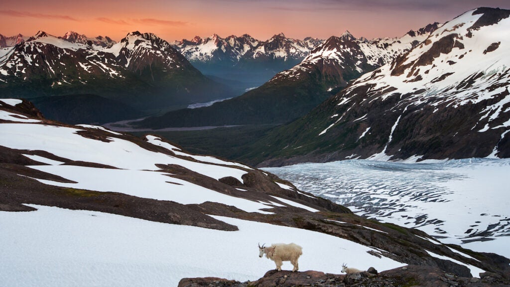
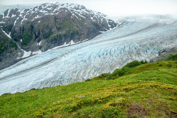
If you live in the Lower 48, a trip to Alaska deserves a slot on your bucket list. While you’re there, there are few dayhikes as worthy of your time as the Harding Icefield trail in Kenai Fjords National Park. The Harding Icefield connects 40 glaciers over 700 square miles, making it the largest icefield located entirely in the United States. Nearly a 2.5-hour drive from Anchorage, this is one of the few maintained trails in the national park, and it gives you a glimpse of the 57 million acres of untouched wilderness in the entire state.
You’ll start from the valley floor and wind through cottonwood and alder forests, passing brown and black bears as you climb peaks well above the treeline to a view of ice and snow. From the top, look out across the field. You’ll find some nunataks, which are lone mountain peaks, sticking out of the snow and ice.
If you’re not interested in hiking the entire trail, there are two places that could serve as turnaround points: Marmot Meadows at 1.4 miles (with plenty of, you guessed it, marmots) and Top of the Cliff (we’ll let you guess what’s there) at 2.4 miles.
Length: 6.7 miles
Elevation Gain: 3,300 feet
Best time to hike: summer to early fall for snow-free trails
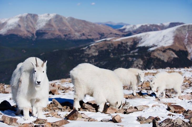
Completing your first 14er is a great bucket list item because although there are no easy 14ers, many have trails short enough that allow you to tag the peak before lunchtime. From the very first step on trail, Quandary is certainly steep—with over 3,000 feet of ascent in 3 miles of climbing—but it’s one of the state’s most popular 14ers to usher first-timers into the world of high-altitude hiking.
The trail, which is a dirt path as you ascend above the treeline and gets rockier as you approach the summit, is Class 1, meaning there’s no technical scrambling. The path is very well-marked and follows the east ridge of the mountain up to the summit. Look out for the mountain goats and pikas that scale the steeps every day. While Quandary is a relatively safe 14er to hike in winter, it’s advisable to bring microspikes and poles if you’re hiking outside of the busy July to September season.
Length: 12.2 miles
Elevation Gain: 1,700 feet
Best time to hike: summer and early fall
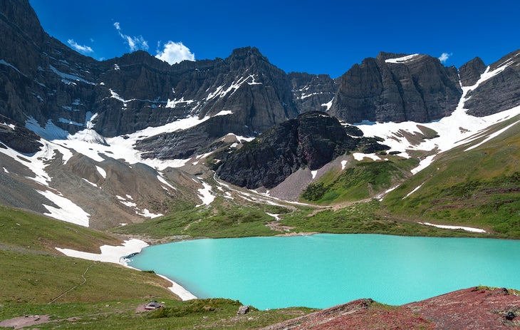
You’ve likely never seen water as turquoise as what’s in Cracker Lake. Many have compared the color to what you’d see on a robin’s egg or on a Tiffany & Co. bag, but really, it looks like someone filled the lake with Glacier Freeze Gatorade and milk—in a beautiful way. The hue is why many consider it one of the most beautiful out of the over 700 lakes in the entire national park.
Seeing it requires a bit of day-of logistical planning. The trailhead shares a parking lot with Many Glacier Hotel, so depending on the season, it can be pretty crowded. However, when Many Glacier Hotel closes for the season (generally between September and June), Cracker Lake hikers don’t need to hunt for a parking spot. On the way to the lake on this trail, you’ll pass many of streams, some of which have crystal-clear water that gives way to eggplant, terracotta, and yellow rocks at the streambed. This trail is home to lots of marmots, bears, moose, and more, so keep your eyes out for wildlife. Also if you’re hiking in the late summer, look for thimbleberries growing on bushes—the fruit looks like raspberries and is safe to eat. When you arrive at Cracker Lake, it’s ok to dip your toes in the mineral-rich ice melt.
A note for in-season 2024 hikers: The park will require vehicle reservations daily for Going-to-the-Sun Road (coming from the west), the North Fork, and Many Glacier from 6 a.m. to 3 p.m. Cracker Lake is in the Many Glacier area, so plan ahead before starting your hike. Each area has separate vehicle reservation requirements, which you can read more about here.
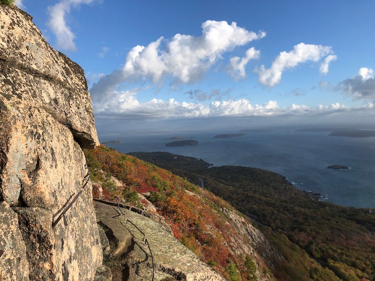
Length: 3.2 miles
Elevation Gain: 1,059 feet
Best time to hike: spring and fall
This famous hike is short, sweet, and steep, so much so that it borders on jungle gym climbing: Using iron rungs and ladders, you’ll ascend a vertical cliff face after traversing narrow ledges past car-size boulders and cliff faces. From the top of Champlain Mountain, the sixth highest peak in the park, hikers have amazing views of Frenchman Bay and all the trees in the distance, which are especially gorgeous as the leaves turn. Time your hike to avoid rain, which makes the rungs and ladders slippery.
This trail isn’t recommended for young children and acrophobes, but there is a solution for those concerned about descending such a steep slope back to the car: Take the North Ridge Trail of Champlain Mountain, a moderately steep descent on granite. Check trail status on the National Park Service’s website before arriving: The Precipice Loop is usually closed between mid-March and mid-August due to peregrine falcon nesting.
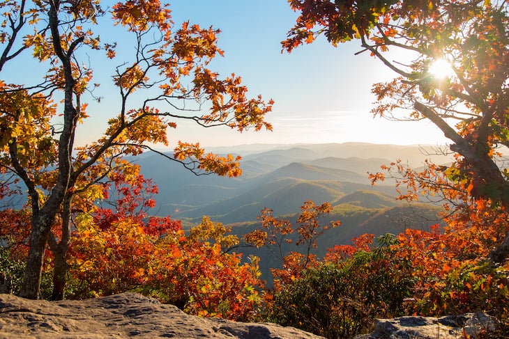
Length: 4.7 miles (from via the Appalachian Trail)
Elevation Gain: 1,400 feet
Best time to hike: year-round
This southern hike has everything: flowing waterfalls, the chance to rub elbows with some AT thru-hikers, and a bear on a cocaine-fueled rampage. The black bears that roam these lands today aren’t chowing down on blow, but back in 1985, these woods are close to where a hunter found Cocaine Bear, made famous in the Elizabeth Banks movie of the same name, dead. At 4,458 feet, the summit of Blood Mountain is Georgia’s section of the Appalachian Trail’s highest point, where you can see the Blue Ridge Mountains and, on a clear day, the Atlanta skyline just over 70 miles away.
There’s also a bit of hiker history on this trail: It’s also home to the first shelter in the state built by the Civilian Conservation Corps in the 1930s, now maintained by the Georgia Appalachian Trail Club. On this steep but easy to follow trail, you’ll hike past red lichen, northern hardwood trees, tulip poplars, and Catawba rhododendron. On the summit, post up on one of the many flat rock formations long enough to set up a picnic lunch before making your descent.
From 2023
